WINTER STORM WARNING ISSUED – A big storm is expected on Sunday, and it could bring up to 10 inches of snow.
Winter Storm Warning: Virginia and Maryland Brace , Baltimore area
VIRGINIA — Updated information about the timing and expected snowfall amounts has been shared ahead of the winter storm expected to hit Northern Virginia on Sunday. The National Weather Service issued a winter storm warning on Saturday for several counties in the Washington, D.C. area, including Loudoun, Warren, and Clarke counties in Virginia. The warning will be active from 7 a.m. Sunday to 7 p.m.
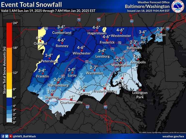
A winter storm watch is still active for Prince William County, starting Sunday morning and lasting through Sunday evening.”Snow will begin spreading across the area Sunday morning, continue into the afternoon, and gradually slow down by evening,” the National Weather Service said. “At times, snow could fall at a rate of 1 inch per hour.”Loudoun County could see up to 4 inches of snow, while the D.C. metro area is likely to get 2-3 inches. Farther south, places like Fredericksburg might get less than an inch.Travel conditions are expected to get worse quickly on Sunday, and strong winds could knock down tree branches, according to forecasters.”Try to avoid traveling if you can,” the National Weather Service advised. “If you absolutely must travel, be extremely cautious and ready for sudden drops in visibility.”After the snow clears out, a polar vortex will move into Northern Virginia. This system usually keeps the coldest air trapped near the North Pole. This will bring bitterly cold and dangerous temperatures to the Baltimore area.
Weather Forecast (Simplified):-
- Here’s a look at the :- https://forecast.weather.gov/MapClick.php?lat=38.8920621&lon=-77.0199124
- Sunday: It will be cold, with temperatures in the 30s during the day, dropping to the mid-20s by Monday. Nighttime temperatures will fall into the single digits but will get slightly warmer on Tuesday. Tuesday’s high will be around 25°F, and the low will be 9°F, according to the National Weather Service.
- Saturday:
- Afternoon: You might see a few light showers between noon and 2 PM. The sky will start off cloudy but should clear up to become mostly sunny later. The temperature will reach around 48°F. Light winds will blow from the south, with occasional stronger gusts. There’s a 30% chance of rain.
- Night: There’s a small chance of rain after 4 AM. The sky will become cloudier, and temperatures will drop to about 32°F. Winds will be calm at first but will shift to the northwest later.
- Sunday:
Snow and rain are expected during the day, turning into all snow by late afternoon. The temperature will reach about 35°F. Winds will pick up from the north, with occasional strong gusts. There’s a 100% chance of precipitation, and 1 to 3 inches of snow is likely.
Get ready for cold weather and snow on Sunday, and try to plan ahead if you need to travel.
Sunday Night: Snow is likely to fall before 7 PM. It will be cloudy in the evening but will clear up later. The temperature will drop to about 19°F. Winds will come from the northwest at 11-18 mph, with gusts up to 28 mph. There’s a 60% chance of snow, and you might get less than half an inch of new snow.
Monday: It will be sunny, but very cold, with a high around 24°F. Winds from the west at 16-18 mph, with gusts reaching up to 33 mph.
Monday Night: The sky will be mostly clear, and temperatures will drop to around 7°F.
Tuesday: It will be mostly cloudy with a high near 25°F.
BALTIMORE, MD
BALTIMORE, MD — The National Weather Service has issued a Winter Storm Warning for parts of Baltimore County on Sunday, January 19, 2025. The warning will be active from 7 AM to 7 PM that day, meaning you should expect snow and potentially hazardous weather conditions during those hours.
Heavy snow is expected across the area on Sunday. Northern Baltimore County could see 3 to 6 inches of snow, while southern Baltimore County and Baltimore City may get 2 to 3 inches.
Travel could be very difficult during the storm, with hazardous conditions affecting the roads. Strong winds might also cause tree branches to fall.
Snow will begin falling Sunday morning and continue into the afternoon, easing up by the evening. At times, snow could accumulate at a rate of about 1 inch per hour.
If you must travel, make sure to keep an extra flashlight, food, and water in your car in case of an emergency. You can check the latest road conditions for your state by calling 5-1-1.
Residents should avoid traveling if possible. If you must go out, drive carefully and be ready for sudden changes in visibility. Leave enough space between your car and others, and allow extra time to get where you’re going. Avoid sudden stops or speeding up, and be extra careful on hills or when turning. Make sure your car is prepared for winter weather and in good working condition.


